
Suburb profile
Nundah QLD 4012
Nundah is located in the Brisbane North region of Queensland, postcode 4012. It has 9,927 properties across 108 streets, mostly units. Explore every street in Nundah, its property history, homes for sale and rent, who lives there, and the local agents.
About Nundah
Nundah, QLD 4012, sits in the Brisbane North region and neighbours Clayfield, Hendra, Kalinga and Northgate. Its 108 streets hold 9,927 properties, 3,164 of them houses and 6,763 units.
At the 2021 Census Nundah had 13,305 residents, a median age of 35 and an average household of 2 people. Median household income was $1,763 a week, the median mortgage repayment $1,733 a month and the median rent $370 a week. Of 6,365 dwellings, 1,488 were separate houses, 1,003 semi-detached and 3,865 flats, with 3 other; 945 were owned outright, 1,789 owned with a mortgage and 3,493 rented.
Updated October 2026
Who lives in Nundah
- 13,305Peoplelive in the area
- 35Median ageyears
- $1,763Median household incomea week
- $370Median renta week
Homes by type
- Houses1,488
- Townhouses and semis1,003
- Flats and apartments3,865
- Other3
Household
- Median mortgage repayment$1,733a month
- Household size2people on average
How homes are held
For sale and rent in Nundah

 Alycia Hoffman
For Sale
7/95 York Street, Nundah QLD
Inspect Sat, 31 Oct 9:00am
 Alycia Hoffman
Offers Over $699,000
5/71 Melton Road, Nundah QLD
Inspect Sat, 31 Oct 10:00am

 Shenal Yigitbas

For Sale
2/24 Attewell Street, Nundah QLD
Inspect Sat, 31 Oct 12:00pm

 Jamie-Lee Cockings
750 per week
1/109 Vernon Street, Nundah QLD
Available now

 Property Management Team
$650 pw
5/32 Collins Street, Nundah QLD
Available Thu, 29 Oct

 Aiden Gourley
$800 pw
4/163 York Street, Nundah QLD
Inspect today 11:50am
Available now
Properties in Nundah

2/81 Eton Street
Leased Nov 2026 · $600 per week
2 bedrooms 2 bathrooms 1 car space

29 Buckland Road
Leased Nov 2026 · $800 per week
3 bedrooms 2 bathrooms 2 car spaces 405 m² land

1/54 Eton Street
Leased Oct 2026 · $520 per week
2 bedrooms 1 bathroom 2 car spaces

3/17 Dwyer Street
Leased Oct 2026 · $600 per week
2 bedrooms 2 bathrooms 1 car space

2/10 Cavendish Street
Leased Oct 2026 · $390 per week
1 bedroom 1 bathroom

406/1 York Street
Leased Oct 2026 · $670 per week
2 bedrooms 1 bathroom 1 car space

1/50 Henchman Street
Leased Oct 2026 · $660 per week
2 bedrooms 1 bathroom 1 car space

6/45 Leslie Street
Leased Oct 2026 · $650 per week
2 bedrooms 1 bathroom 1 car space

607/26 Station Street
Sold Oct 2026 · Contact agent
1 bedroom 1 bathroom 1 car space

5/632 Nudgee Road
Sold Sept 2026 · $770,000
2 bedrooms 2 bathrooms 1 car space
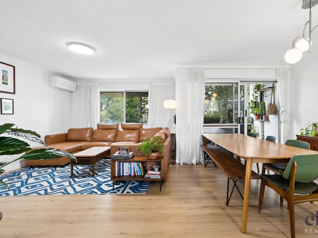
2/22 Collins Street
Sold Sept 2026 · $738,000
2 bedrooms 1 bathroom 1 car space

4/25 Railway Parade
Sold Sept 2026 · Contact agent
2 bedrooms 2 bathrooms 2 car spaces

6/26 Kreutzer Street
Sold Sept 2026 · $725,000
2 bedrooms 1 bathroom 2 car spaces

4/26 Windsor Street
Sold Aug 2026 · Contact agent
2 bedrooms 1 bathroom 1 car space

5/17 Mcmaster Street
Sold Aug 2026 · Contact agent
2 bedrooms 2 bathrooms 1 car space 97 m² land

4/20 Newby Street
Sold Aug 2026 · $720,000
2 bedrooms 1 bathroom 1 car space
Schools in Nundah
Northgate State School
GovernmentPrimary
Nundah State School
GovernmentPrimary
St Joseph's School
CatholicPrimary
Mary MacKillop College
CatholicSecondary
Local agents in Nundah
Alycia Hoffman
Sales Agent Coronis Ascot
Last 12 months
- Properties sold
- 11
- Median sold price
- $740k
- Median days on market
- 29

Ireland Knowles
Sales Agent Coronis North
Last 12 months
- Properties sold
- 6
- Median sold price
- $724k
- Median days on market
- 29

Jordan Cleland
Sales Manager Clark Real Estate
Last 12 months
- Properties sold
- 56
- Median sold price
- $830k
- Median days on market
- 45
Agencies that specialise in Nundah
All 17 agencies in Nundah
Streets in Nundah
A
B
C
D
E
F
G
H
I
J
K
L
M
N
O
P
R
S
T
U
V
W
Y
Neighbouring suburbs
Addresses and streets incorporate or were developed using G-NAF © Geoscape Australia, licensed by the Commonwealth of Australia under the Open Geo-coded National Address File (G-NAF) End User Licence Agreement.
Population and housing figures are drawn from the Australian Bureau of Statistics, Census of Population and Housing 2021, licensed under Creative Commons Attribution 4.0 International.
School details © Australian Curriculum, Assessment and Reporting Authority (ACARA), from the Australian Schools List, licensed under Creative Commons Attribution 4.0 International and modified. ACARA does not endorse Listd.
Area summaries are generated from the national address file and ABS Census data, and checked against those figures before publication.