
Suburb profile
Earlwood NSW 2206
Earlwood is located in the Inner South West region of New South Wales, postcode 2206. It has 8,338 properties across 158 streets, mostly houses. Explore every street in Earlwood, its property history, homes for sale and rent, who lives there, and the local agents.
About Earlwood
Earlwood, NSW 2206, sits in the Inner South West region and neighbours Bardwell Park, Bardwell Valley, Bexley North and Campsie. Its 158 streets hold 8,338 properties, 6,549 of them houses and 1,789 units.
At the Census Earlwood had 17,969 residents, a median age of 44 and an average household of 2.8 people. Median household income was $2,163 a week, the median mortgage repayment $2,809 a month and the median rent $570 a week. Of 6,109 dwellings, 4,897 were separate houses, 501 semi-detached and 703 flats; 5 were other dwellings. Of the 6,109 households, 2,720 owned outright, 1,984 owned with a mortgage and 1,254 rented.
Updated October 2026
Who lives in Earlwood
- 17,969Peoplelive in the area
- 44Median ageyears
- $2,163Median household incomea week
- $570Median renta week
Homes by type
- Houses4,897
- Townhouses and semis501
- Flats and apartments703
- Other5
Household
- Median mortgage repayment$2,809a month
- Household size2.8people on average
How homes are held
Properties in Earlwood

12 Hansen Avenue
Leased Sept 2026 · $1,150 per week
3 bedrooms 1 bathroom 1 car space

9A David Street
Sold Aug 2026 · $1,376,000
5 bedrooms 2 bathrooms 1 car space 525 m² land
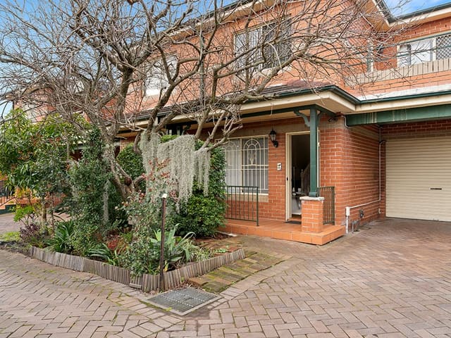
4/84-86 William Street
Sold Aug 2026 · $1,310,000
3 bedrooms 1 bathroom 2 car spaces

25/156-158 Homer Street
Leased June 2026 · $550 per week
1 bedroom 1 bathroom 1 car space

17/103-107 Homer Street
Leased Apr 2026 · $680 per week
2 bedrooms 1 bathroom 1 car space

4/168 Homer Street
Sold Apr 2026 · $940,000
2 bedrooms 1 bathroom 1 car space

110 Woolcott Street
Sold Feb 2026 · $2,770,000
5 bedrooms 4 bathrooms 6 car spaces 435.8 m² land

43 Prince Edward Avenue
Leased May 2024 · $1,100 per week
3 bedrooms 2 bathrooms 2 car spaces
9A David Street
Sold Aug 2026 · $1,376,000
5 bedrooms 2 bathrooms 1 car space 525 m² land
4/84-86 William Street
Sold Aug 2026 · $1,310,000
3 bedrooms 1 bathroom 2 car spaces
4/168 Homer Street
Sold Apr 2026 · $940,000
2 bedrooms 1 bathroom 1 car space
110 Woolcott Street
Sold Feb 2026 · $2,770,000
5 bedrooms 4 bathrooms 6 car spaces 435.8 m² land

19/156-158 Homer Street
Sold Apr 2024 · $849,000
2 bedrooms 1 bathroom 1 car space

12 Bardwell Crescent
Sold July 2021 · $1,950,000
5 bedrooms 2 bathrooms 2 car spaces 467 m² land

119 Wardell Road
Sold Dec 2019 · Contact agent
3 bedrooms 2 bathrooms 1 car space
Schools in Earlwood
Clemton Park Public School
GovernmentPrimary
Earlwood Public School
GovernmentPrimary
Our Lady of Lourdes Catholic Primary School
CatholicPrimary
Undercliffe Public School
GovernmentPrimary
No secondary schools in Earlwood.
Agencies that specialise in Earlwood
All 5 agencies in Earlwood


Streets in Earlwood
A
B
- Bamboo Avenue15 properties
- Banks Road86 properties
- Bankside Avenue15 properties
- Bardwell Crescent35 properties
- Baringa Road42 properties
- Barnes Avenue32 properties
- Bass Road117 properties
- Bayview Avenue218 properties
- Bedford Street61 properties
- Bexley Road140 properties
- Birrellea Avenue31 properties
- Boomerang Avenue28 properties
- Braeside Crescent20 properties
- Bramston Avenue35 properties
- Bray Avenue27 properties
- Burlington Avenue56 properties
C
D
E
F
G
H
I
J
K
L
M
N
O
P
R
S
T
U
V
W
- Wanstead Avenue26 properties
- Warburton Parade33 properties
- Wardell Road323 properties
- Waterside Crescent53 properties
- Watkin Avenue14 properties
- Wavell Parade20 properties
- Waygrove Avenue18 properties
- Wellington Road30 properties
- Westfield Street36 properties
- William Street395 properties
- Willunga Avenue24 properties
- Winston Avenue23 properties
- Wolli Avenue116 properties
- Woodlawn Avenue39 properties
- Woods Parade17 properties
- Woolcott Street181 properties
- Wyatt Avenue17 properties
Y
Neighbouring suburbs
Addresses and streets incorporate or were developed using G-NAF © Geoscape Australia, licensed by the Commonwealth of Australia under the Open Geo-coded National Address File (G-NAF) End User Licence Agreement.
Population and housing figures are drawn from the Australian Bureau of Statistics, Census of Population and Housing 2021, licensed under Creative Commons Attribution 4.0 International.
School details © Australian Curriculum, Assessment and Reporting Authority (ACARA), from the Australian Schools List, licensed under Creative Commons Attribution 4.0 International and modified. ACARA does not endorse Listd.
Area summaries are generated from the national address file and ABS Census data, and checked against those figures before publication.