
Suburb profile
Stafford QLD 4053
Stafford is located in the Brisbane North region of Queensland, postcode 4053. It has 4,543 properties across 96 streets. Explore every street in Stafford, its property history, homes for sale and rent, who lives there, and the local agents.
About Stafford
Stafford, QLD 4053, sits in Brisbane North and neighbours Alderley, Enoggera, Gordon Park and Grange. Its 96 streets hold 4,543 properties, 2,853 of them houses and 1,690 units.
At the Census Stafford had 6,917 residents, a median age of 35 and an average household of 2.2 people. Median household income was $1,762 a week, the median mortgage repayment $2,000 a month and the median rent $360 a week. Of 2,893 dwellings, 1,965 were separate houses, 253 semi-detached and 676 flats; 549 were owned outright, 882 owned with a mortgage and 1,398 rented.
Updated October 2026
Who lives in Stafford
- 6,917Peoplelive in the area
- 35Median ageyears
- $1,762Median household incomea week
- $360Median renta week
Homes by type
- Houses1,965
- Townhouses and semis253
- Flats and apartments676
Household
- Median mortgage repayment$2,000a month
- Household size2.2people on average
How homes are held
For sale and rent in Stafford
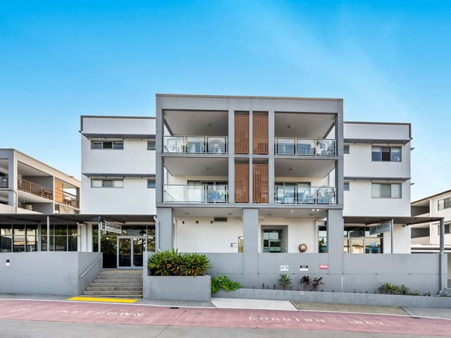
 Alycia Hoffman
Offers Over $599,000
125/6 Babarra Street, Stafford QLD
Inspect Sat, 31 Oct 11:00am

 Kathy Novacsek

Offers over $1.015M
539 Stafford Road, Stafford QLD 4053
Inspect Sat, 31 Oct 10:00am

 Adam Bryant

For Sale
38 Crawford Avenue, Stafford QLD

 Ben Stay
$730 Per Week
114 Armfield Street, Stafford QLD
Available now
Properties in Stafford

125/6 Babarra Street
For sale since Oct 2026 · Offers Over $599,000
1 bedroom 1 bathroom 1 car space

76 Webb Street
Leased Oct 2026 · $675 per week
3 bedrooms 1 bathroom 2 car spaces 668 m² land

539 Stafford Road
For sale since Oct 2026 · Offers over $1.015M
3 bedrooms 1 bathroom 2 car spaces 607 m² land

34 Reuben Street
Sold Oct 2026 · Contact agent
3 bedrooms 1 bathroom 2 car spaces 546 m² land

38 Crawford Avenue
For sale since Oct 2026 · For Sale
3 bedrooms 1 bathroom 2 car spaces 433 m² land

108 Appleby Road
Leased Oct 2026 · $650 per week
3 bedrooms 1 bathroom 1 car space

231 Webster Road
Leased Oct 2026 · $620 per week
2 bedrooms 1 bathroom 2 car spaces

118 Pateena Street
Leased Sept 2026 · $800 per week
3 bedrooms 1 bathroom 410 m² land
34 Reuben Street
Sold Oct 2026 · Contact agent
3 bedrooms 1 bathroom 2 car spaces 546 m² land

31 Burrowa Street
Sold Sept 2026 · Contact agent
4 bedrooms 2 bathrooms 1 car space 807 m² land

15 Turrana Street
Sold Aug 2026 · $1,280,000
3 bedrooms 1 bathroom 2 car spaces 407 m² land

11 Reuben Street
Sold July 2026 · $1,370,000
2 bedrooms 2 bathrooms 1 car space 539 m² land

55 Appleby Road
Sold May 2026 · $1,250,000
3 bedrooms 1 bathroom 2 car spaces 405 m² land

33 Quandeine Street
Sold May 2026 · $1,885,000
4 bedrooms 2 bathrooms 4 car spaces 591 m² land

35 Gort Crescent
Sold Apr 2026 · $1,500,000
4 bedrooms 3 bathrooms 2 car spaces 151 m² land

6 Longland Street
Sold Apr 2026 · $1,740,000
3 bedrooms 1 bathroom 1 car space 1,067 m² land
Schools in Stafford
Queen of Apostles Primary School
CatholicPrimary
Stafford State School
GovernmentPrimary
No secondary schools in Stafford.
Local agents in Stafford

Tania Mathers
Real Estate Agent Harcourts Solutions - Alderley
Last 12 months
- Properties sold
- 15
- Median sold price
- $1.28m
- Median days on market
- 30

Emily Magee
Real Estate Agent Harcourts Solutions - Windsor
Last 12 months
- Properties sold
- 8
- Median sold price
- $1.2m
- Median days on market
- 33
Last 12 months
- Properties sold
- 14
- Median sold price
- $890k
- Median days on market
- 43
Agencies that specialise in Stafford
All 10 agencies in Stafford
Streets in Stafford
A
B
- Babarra Street177 properties
- Balal Street19 properties
- Balerang Street26 properties
- Barbigal Street54 properties
- Barellan Street17 properties
- Barokee Street47 properties
- Berpi Street8 properties
- Bertram Street31 properties
- Billabong Street35 properties
- Bilston Street21 properties
- Boles Street6 properties
- Brennan Street14 properties
- Brockman Street14 properties
- Buddina Street61 properties
- Burrowa Street25 properties
- Byth Street86 properties
C
D
E
F
G
H
J
K
L
M
N
O
P
Q
R
S
T
V
W
Neighbouring suburbs
Addresses and streets incorporate or were developed using G-NAF © Geoscape Australia, licensed by the Commonwealth of Australia under the Open Geo-coded National Address File (G-NAF) End User Licence Agreement.
Population and housing figures are drawn from the Australian Bureau of Statistics, Census of Population and Housing 2021, licensed under Creative Commons Attribution 4.0 International.
School details © Australian Curriculum, Assessment and Reporting Authority (ACARA), from the Australian Schools List, licensed under Creative Commons Attribution 4.0 International and modified. ACARA does not endorse Listd.
Area summaries are generated from the national address file and ABS Census data, and checked against those figures before publication.