
Suburb profile
Montrose TAS 7010
Montrose is located in the Hobart region of Tasmania, postcode 7010. It has 1,261 properties across 30 streets, mostly houses. Explore every street in Montrose, its property history, homes for sale and rent, who lives there, and the local agents.
About Montrose
Montrose, TAS 7010, sits in the Hobart region and neighbours Collinsvale, Glenorchy, Wellington Park and Rosetta. Its 30 streets hold 1,261 properties, 879 of them houses and 382 units.
Census figures are for the Montrose - Rosetta area, which has 5,142 residents, a median age of 41 and an average household of 2.4 people. Median household income is $1,434 a week, the median mortgage repayment $1,448 a month and the median rent $350 a week. Of 2,037 dwellings, 1,663 are separate houses, 20 semi-detached, 350 flats and 8 other; 725 are owned outright, 681 owned with a mortgage and 579 rented.
Updated October 2026
Who lives in Montrose
- 5,142Peoplelive in the area
- 41Median ageyears
- $1,434Median household incomea week
- $350Median renta week
Homes by type
- Houses1,663
- Townhouses and semis20
- Flats and apartments350
- Other8
Household
- Median mortgage repayment$1,448a month
- Household size2.4people on average
How homes are held
For sale and rent in Montrose
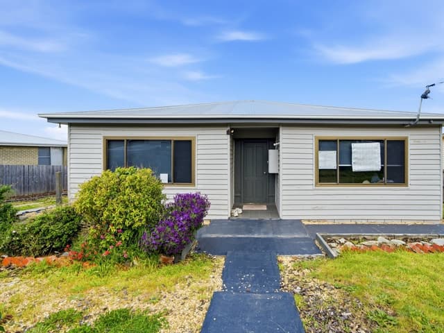
 Aaron Murray

$695,000 +
31 Huntley Street, Montrose TAS 7010
Properties in Montrose

31 Huntley Street
For sale since Oct 2026 · $695,000 +
3 bedrooms 2 bathrooms 2 car spaces 706 m² land

1 Oakbank Avenue
Sold Aug 2026 · $675,000
3 bedrooms 1 bathroom 2 car spaces 619 m² land

27 Islington Road
Sold July 2026 · $740,000
3 bedrooms 1 bathroom 3 car spaces 1,541 m² land
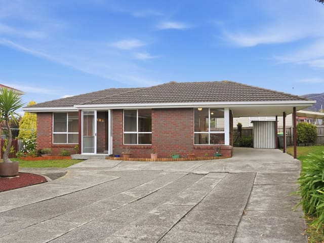
2/2 Duncan Street
Sold June 2026 · $540,000
2 bedrooms 1 bathroom 1 car space 371 m² land

4 Herbert Street
Sold Apr 2026 · $700,000
3 bedrooms 1 bathroom 3 car spaces 959 m² land

5/476A Main Road
Sold Apr 2026 · $520,000
2 bedrooms 1 bathroom 247 m² land

2/519 Main Road
Sold Apr 2026 · $250,000
325 m² land

3/476A Main Road
Sold Mar 2026 · $620,000
2 bedrooms 1 bathroom 3 car spaces 336 m² land
1 Oakbank Avenue
Sold Aug 2026 · $675,000
3 bedrooms 1 bathroom 2 car spaces 619 m² land
27 Islington Road
Sold July 2026 · $740,000
3 bedrooms 1 bathroom 3 car spaces 1,541 m² land
2/2 Duncan Street
Sold June 2026 · $540,000
2 bedrooms 1 bathroom 1 car space 371 m² land
4 Herbert Street
Sold Apr 2026 · $700,000
3 bedrooms 1 bathroom 3 car spaces 959 m² land
5/476A Main Road
Sold Apr 2026 · $520,000
2 bedrooms 1 bathroom 247 m² land
2/519 Main Road
Sold Apr 2026 · $250,000
325 m² land
3/476A Main Road
Sold Mar 2026 · $620,000
2 bedrooms 1 bathroom 3 car spaces 336 m² land

15 Tilyard Street
Sold Mar 2026 · $750,000
3 bedrooms 1 bathroom 4 car spaces 1,416 m² land
Local agents in Montrose

Ladence Tandukar
Personal Assistant to Aaron Murray 4one4 Property Co.
Last 12 months
- Properties sold
- 147
- Median sold price
- $650k
- Median days on market
- 28
Aaron Murray
Sales Agent 4one4 Property Co.
Last 12 months
- Properties sold
- 153
- Median sold price
- $650k
- Median days on market
- 28

Shaun McGuire
Sales Consultant 4one4 Property Co.
Last 12 months
- Properties sold
- 14
- Median sold price
- $615k
- Median days on market
- 33
Agencies that specialise in Montrose
Streets in Montrose
- Beneve Court8 properties
- Brooker Highway3 properties
- Cheltenham Street38 properties
- Croyden Avenue21 properties
- Duncan Street32 properties
- England Avenue26 properties
- Fosbrook Court30 properties
- Fowler Street25 properties
- Galston Road24 properties
- Herbert Street41 properties
- Huntley Street46 properties
- Islington Road58 properties
- Jasanda Drive64 properties
- Katoomba Crescent18 properties
- Main Road159 properties
- Montrose Road202 properties
- Morriss Avenue10 properties
- Nambour Place17 properties
- Newton Court7 properties
- Nielson Drive16 properties
- Oakbank Avenue18 properties
- Philip Avenue75 properties
- Pitcairn Street54 properties
- Riverway Road68 properties
- Ruthwell Street16 properties
- Shenstone Place41 properties
- Tilyard Street90 properties
- Vernon Avenue15 properties
- Victor Place2 properties
- Weston Place37 properties
Neighbouring suburbs
Addresses and streets incorporate or were developed using G-NAF © Geoscape Australia, licensed by the Commonwealth of Australia under the Open Geo-coded National Address File (G-NAF) End User Licence Agreement.
Population and housing figures are drawn from the Australian Bureau of Statistics, Census of Population and Housing 2021, licensed under Creative Commons Attribution 4.0 International.
Area summaries are generated from the national address file and ABS Census data, and checked against those figures before publication.