
Suburb profile
Kenmore Hills QLD 4069
Kenmore Hills is located in the Brisbane West region of Queensland, postcode 4069. It has 1,057 properties across 50 streets, mostly houses. Explore every street in Kenmore Hills, its property history, homes for sale and rent, who lives there, and the local agents.
About Kenmore Hills
Kenmore Hills, QLD 4069, sits in the Brisbane West region and neighbours Brookfield, Kenmore, Mount Coot-Tha and Chapel Hill. Its 50 streets hold 1,057 properties, 914 of them houses and 143 units.
Census figures are for Brookfield - Kenmore Hills, an area that includes most of the suburb. It had 7,020 residents, a median age of 46 and an average household of 3 people. Median household income was $3,239 a week, the median mortgage repayment $2,700 a month and the median rent $520 a week. Of 2,215 dwellings, 2,046 were separate houses, 67 semi-detached and 95 flats; 1,024 were owned outright, 906 owned with a mortgage and 228 rented.
Updated October 2026
Who lives in Kenmore Hills
- 7,020Peoplelive in the area
- 46Median ageyears
- $3,239Median household incomea week
- $520Median renta week
Homes by type
- Houses2,046
- Townhouses and semis67
- Flats and apartments95
Household
- Median mortgage repayment$2,700a month
- Household size3people on average
How homes are held
For sale and rent in Kenmore Hills
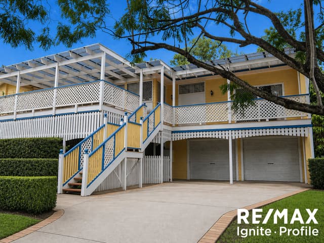
 Roxanne Workman

$925 per week
5 Castlewood Close, Kenmore Hills QLD 4069
Available now
Properties in Kenmore Hills

5 Castlewood Close
For rent since Oct 2026 · $925 per week
4 bedrooms 2 bathrooms 2 car spaces 152 m² land

9 Regency Place
Leased July 2026 · $825 per week
4 bedrooms 2 bathrooms 2 car spaces

359 Brookfield Road
Leased May 2026 · $1,200 per week
4 bedrooms 3 bathrooms 3 car spaces 12,900 m² land

22 Mirbelia Street
Leased Jan 2026 · $930 per week
6 bedrooms 2 bathrooms 2 car spaces 894 m² land

25 Regency Place
Leased Oct 2025 · $1,050 per week
5 bedrooms 3 bathrooms 4 car spaces 738 m² land

6 Tuckett Street
Sold Aug 2025 · $1,450,000
4 bedrooms 2 bathrooms 2 car spaces 1,199 m² land

16 Mirbelia Street
Sold Oct 2023 · $1,250,000
4 bedrooms 2 bathrooms 2 car spaces 856 m² land

74 Bielby Road
Sold Jan 2023 · $1,405,000
5 bedrooms 3 bathrooms 2 car spaces 808 m² land
6 Tuckett Street
Sold Aug 2025 · $1,450,000
4 bedrooms 2 bathrooms 2 car spaces 1,199 m² land
16 Mirbelia Street
Sold Oct 2023 · $1,250,000
4 bedrooms 2 bathrooms 2 car spaces 856 m² land
74 Bielby Road
Sold Jan 2023 · $1,405,000
5 bedrooms 3 bathrooms 2 car spaces 808 m² land

6 Mondra Street
Sold Nov 2022 · $1,075,000
3 bedrooms 3 bathrooms 3 car spaces 733 m² land
Local agents in Kenmore Hills
Roxanne Workman
Principal/Business Owner REMAX Ignite-Profile - Middle Park
Last 12 months
- Properties sold
- 27
- Median sold price
- $969k
- Median days on market
- 24

Lauren Martin
Property Manager 4069 Real Estate

Elle Moyle
Property Manager 4069 Real Estate
Agencies that specialise in Kenmore Hills

Streets in Kenmore Hills
A
B
C
D
E
G
H
J
K
M
P
R
S
T
V
W
Neighbouring suburbs
Addresses and streets incorporate or were developed using G-NAF © Geoscape Australia, licensed by the Commonwealth of Australia under the Open Geo-coded National Address File (G-NAF) End User Licence Agreement.
Population and housing figures are drawn from the Australian Bureau of Statistics, Census of Population and Housing 2021, licensed under Creative Commons Attribution 4.0 International.
Area summaries are generated from the national address file and ABS Census data, and checked against those figures before publication.