
Suburb profile
North Plympton SA 5037
North Plympton is located in the Adelaide West region of South Australia, postcode 5037. It has 2,285 properties across 40 streets. Explore every street in North Plympton, its property history, homes for sale and rent, who lives there, and the local agents.
About North Plympton
North Plympton, SA 5037, sits in the Adelaide West region and neighbours Adelaide Airport, Camden Park, Kurralta Park and Netley. Its 40 streets hold 2,285 properties, 1,525 of them houses and 760 units.
Census figures are for the Plympton area. At the 2021 Census it had 26,480 residents, a median age of 36 and an average household of 2.3 people. Median household income was $1,551 a week, the median mortgage repayment $1,733 a month and the median rent $300 a week. Of 10,890 dwellings, 6,338 were separate houses, 2,838 semi-detached, 1,690 flats and 9 other; 2,893 were owned outright, 3,336 owned with a mortgage and 4,171 rented.
Updated October 2026
Who lives in North Plympton
- 26,480Peoplelive in the area
- 36Median ageyears
- $1,551Median household incomea week
- $300Median renta week
Homes by type
- Houses6,338
- Townhouses and semis2,838
- Flats and apartments1,690
- Other9
Household
- Median mortgage repayment$1,733a month
- Household size2.3people on average
How homes are held
For sale and rent in North Plympton


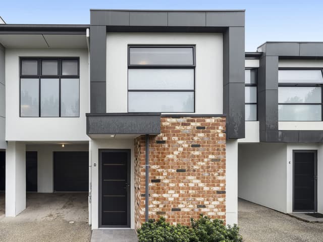
 Kerri Whiteway

$750 per week
14D Talbot Avenue, North Plympton SA 5037
Inspect tomorrow 4:45pm
Available Fri, 30 Oct
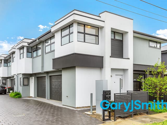
 Alisha Kinchington
$650 per week
3a Dudley Avenue, North Plympton SA 5037
Inspect today 4:45pm
Available Fri, 6 Nov

 Emma Norman

$800 pw
8A Mackay Avenue, North Plympton SA 5037
Available Fri, 13 Nov
Properties in North Plympton

14D Talbot Avenue
For rent since Oct 2026 · $750 per week
3 bedrooms 2 bathrooms 2 car spaces

3A Dudley Avenue
For rent since Oct 2026 · $650 per week
2 bedrooms 1 bathroom 1 car space

5/1 Mcewin Avenue
For sale since Sept 2026 · $790,000 - $820,000
2 bedrooms 1 bathroom 2 car spaces

4/4 Packard Street
Leased Sept 2026 · $530 per week
2 bedrooms 1 bathroom 1 car space

8 Dingera Avenue
Leased Aug 2026 · $680 per week
3 bedrooms 2 bathrooms 2 car spaces

7A Murdoch Avenue
Leased Aug 2026 · $820 per week
3 bedrooms 2 bathrooms 2 car spaces

26 Galway Avenue
Leased Aug 2026 · $695 per week
3 bedrooms 2 bathrooms 1 car space

35 Dingera Avenue
Sold June 2026 · Contact agent
3 bedrooms 2 bathrooms 1 car space 383 m² land
35 Dingera Avenue
Sold June 2026 · Contact agent
3 bedrooms 2 bathrooms 1 car space 383 m² land

8 Lewis Crescent
Sold Mar 2026 · $1,190,000
4 bedrooms 1 bathroom 3 car spaces 828 m² land

30 Bransby Avenue
Sold Mar 2026 · $1,552,000
3 bedrooms 1 bathroom 2 car spaces

48 Streeters Road
Sold Mar 2026 · $1,277,000
3 bedrooms 1 bathroom 2 car spaces 837 m² land

10 Park Terrace
Sold Feb 2026 · $1,768,000
3 bedrooms 1 bathroom 2 car spaces 780 m² land

60 Dingera Avenue
Sold Dec 2025 · Contact agent
3 bedrooms 1 bathroom 3 car spaces

1/2 Dudley Avenue
Sold Oct 2025 · $440,000
1 bedroom 1 bathroom 1 car space

1/9 Mcewin Avenue
Sold Sept 2025 · $761,000
2 bedrooms 1 bathroom 1 car space
Local agents in North Plympton

Todd Foulds
Property Consultant Gary J Smith Real Estate
Last 12 months
- Properties sold
- 22
- Median sold price
- $990k
- Median days on market
- 29

Last 12 months
- Properties sold
- 84
- Median sold price
- $980k
- Median days on market
- 14

Nathan Clegg
Property Consultant Gary J Smith Real Estate
Last 12 months
- Properties sold
- 42
- Median sold price
- $905k
- Median days on market
- 14

Agencies that specialise in North Plympton
Streets in North Plympton
- Allchurch Avenue92 properties
- Beare Avenue21 properties
- Birdwood Close6 properties
- Birdwood Terrace74 properties
- Bransby Avenue81 properties
- Byron Avenue13 properties
- Coulter Street1 property
- Deeds Road34 properties
- Dingera Avenue97 properties
- Dudley Avenue91 properties
- Edward Davies Street13 properties
- Errington Street29 properties
- Galway Avenue82 properties
- Hawson Avenue91 properties
- Inverell Avenue36 properties
- Keith Avenue120 properties
- Kinkaid Avenue52 properties
- Laverack Road33 properties
- Lea Street11 properties
- Lehmann Street21 properties
- Lewis Crescent14 properties
- Mackay Avenue49 properties
- Marion Road501 properties
- Mcewin Avenue33 properties
- Mooringe Avenue98 properties
- Morphett Road8 properties
- Murdoch Avenue57 properties
- Neston Avenue26 properties
- Packard Street100 properties
- Packer Avenue7 properties
- Padman Street18 properties
- Park Terrace9 properties
- Raymond Avenue37 properties
- Shelley Avenue20 properties
- Speed Avenue30 properties
- Spring Street64 properties
- Starr Avenue36 properties
- Streeters Road47 properties
- Talbot Avenue91 properties
- Wyatt Street42 properties
Neighbouring suburbs
Addresses and streets incorporate or were developed using G-NAF © Geoscape Australia, licensed by the Commonwealth of Australia under the Open Geo-coded National Address File (G-NAF) End User Licence Agreement.
Population and housing figures are drawn from the Australian Bureau of Statistics, Census of Population and Housing 2021, licensed under Creative Commons Attribution 4.0 International.
Area summaries are generated from the national address file and ABS Census data, and checked against those figures before publication.