
Suburb profile
Como NSW 2226
Como is located in the Sutherland Shire region of New South Wales, postcode 2226. It has 1,558 properties across 38 streets, almost all houses. Explore every street in Como, its property history, homes for sale and rent, who lives there, and the local agents.
About Como
Como, NSW 2226, sits in the Sutherland Shire and neighbours Bonnet Bay, Illawong, Jannali and Oatley. Its 38 streets hold 1,558 properties, 1,411 of them houses and 147 units.
Census figures are for the Oyster Bay - Como - Jannali area, which had 22,063 residents, a median age of 40 and an average household of 2.9 people. Median household income was $2,745 a week, the median mortgage repayment $3,000 a month and the median rent $500 a week. Of 7,383 dwellings, 5,586 were separate houses, 1,150 semi-detached, 622 flats and 18 other; 2,788 were owned outright, 3,391 owned with a mortgage and 1,095 rented.
Updated October 2026
Who lives in Como
- 22,063Peoplelive in the area
- 40Median ageyears
- $2,745Median household incomea week
- $500Median renta week
Homes by type
- Houses5,586
- Townhouses and semis1,150
- Flats and apartments622
- Other18
Household
- Median mortgage repayment$3,000a month
- Household size2.9people on average
How homes are held
For sale and rent in Como

 Danny Fox

For Sale
65 Woronora Crescent, Como NSW
Inspect tomorrow 1:45pm


$920 Per Week
1/35 Girraween Avenue, Como NSW 2226
Inspect tomorrow 2:45pm
Available now
Properties in Como
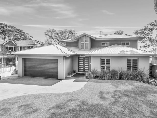
17 Wollun Street
Sold Oct 2026 · $3,140,000
5 bedrooms 3 bathrooms 2 car spaces 822 m² land
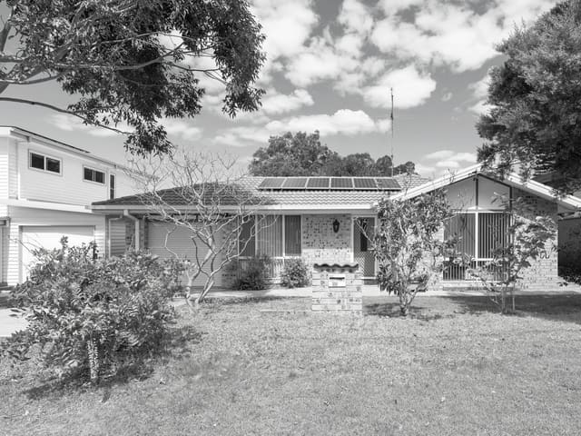
26 Bindea Street
Sold Oct 2026 · Contact agent
3 bedrooms 2 bathrooms 1 car space 783.5 m² land

65 Woronora Crescent
For sale since Oct 2026 · For Sale
4 bedrooms 3 bathrooms 1 car space 759 m² land

65 Warraba Street
Sold Sept 2026 · $1,050,000
2 bedrooms 1 bathroom 1 car space

1/35 Girraween Avenue
For rent since Sept 2026 · $920 per week
3 bedrooms 2 bathrooms 2 car spaces

3 Bream Street
Sold Aug 2026 · $1,900,000
4 bedrooms 2 bathrooms 2 car spaces 619 m² land

9 Novara Crescent
Leased June 2026 · $1,800 per week
7 bedrooms 3 bathrooms 4 car spaces

8 Loretta Avenue
Sold June 2026 · $1,660,000
3 bedrooms 2 bathrooms 2 car spaces 569 m² land
17 Wollun Street
Sold Oct 2026 · $3,140,000
5 bedrooms 3 bathrooms 2 car spaces 822 m² land
26 Bindea Street
Sold Oct 2026 · Contact agent
3 bedrooms 2 bathrooms 1 car space 783.5 m² land
65 Warraba Street
Sold Sept 2026 · $1,050,000
2 bedrooms 1 bathroom 1 car space
3 Bream Street
Sold Aug 2026 · $1,900,000
4 bedrooms 2 bathrooms 2 car spaces 619 m² land
8 Loretta Avenue
Sold June 2026 · $1,660,000
3 bedrooms 2 bathrooms 2 car spaces 569 m² land

23 Yamba Road
Sold May 2026 · $2,010,000
4 bedrooms 2 bathrooms 2 car spaces 550 m² land

112 Wolger Street
Sold Apr 2026 · Contact agent
3 bedrooms 1 bathroom 3 car spaces 563 m² land

30 Woronora Crescent
Sold Mar 2026 · Contact agent
4 bedrooms 2 bathrooms 2 car spaces 556 m² land
Schools in Como
Como Public School
GovernmentPrimary
Como West Public School
GovernmentPrimary
St Joseph's Catholic Primary School Como - Oyster Bay
CatholicPrimary
No secondary schools in Como.
Local agents in Como

Jed Wood
Director Fox & Wood
Last 12 months
- Properties sold
- 75
- Median sold price
- $1.59m
- Median days on market
- 22

Shane Flanagan
Sales Agent Fox & Wood
Last 12 months
- Properties sold
- 53
- Median sold price
- $1.5m
- Median days on market
- 21
Danny Fox
Director Fox & Wood
Last 12 months
- Properties sold
- 78
- Median sold price
- $1.55m
- Median days on market
- 22
Agencies that specialise in Como
Streets in Como
- Bindea Street27 properties
- Binya Place36 properties
- Bonnet Avenue25 properties
- Bream Street14 properties
- Bulumin Street28 properties
- Burke Street6 properties
- Burunda Street33 properties
- Central Avenue66 properties
- Como Parade86 properties
- Cremona Road80 properties
- Currah Road17 properties
- Currawang Place11 properties
- Doveleys Road14 properties
- Evans Street10 properties
- Genoa Street10 properties
- Girraween Avenue60 properties
- Highpoint Place5 properties
- Inelgah Road35 properties
- Keele Street18 properties
- Loretta Avenue15 properties
- Mindar Street11 properties
- Mulyan Street97 properties
- Novara Crescent114 properties
- Ortona Parade15 properties
- Oyster Bay Road12 properties
- Pavia Road3 properties
- Prospect Place17 properties
- Railway Road1 property
- Taplan Street12 properties
- Taronga Street12 properties
- Tivoli Esplanade48 properties
- Verona Range26 properties
- Warraba Street74 properties
- Wigens Avenue22 properties
- Wolger Street138 properties
- Wollun Street88 properties
- Woronora Crescent211 properties
- Yamba Road61 properties
Neighbouring suburbs
Addresses and streets incorporate or were developed using G-NAF © Geoscape Australia, licensed by the Commonwealth of Australia under the Open Geo-coded National Address File (G-NAF) End User Licence Agreement.
Population and housing figures are drawn from the Australian Bureau of Statistics, Census of Population and Housing 2021, licensed under Creative Commons Attribution 4.0 International.
School details © Australian Curriculum, Assessment and Reporting Authority (ACARA), from the Australian Schools List, licensed under Creative Commons Attribution 4.0 International and modified. ACARA does not endorse Listd.
Area summaries are generated from the national address file and ABS Census data, and checked against those figures before publication.